


elghonaimy, I.*, Moosa, S.**
eelghonaimy@uob.edu.bh, seifmossa56@gmail.com
*University Of Bahrain, College of Engineering, Department of Architecture and Interior Design.
**Freelance Landscape Architect, Kingdom of Bahrain
Abstract #
As urban environments continue to grow and face the challenges of resource constraints, the need for efficient and sustainable landscape maintenance practices becomes increasingly evident. This research paper explores integrating digital tools and data analytics to optimize sustainable landscape maintenance techniques, foster resource-efficient practices, and promote ecological preservation. The study focuses on implementing cutting-edge technologies, such as Internet of Things (IoT) sensors, remote monitoring systems, and data-driven decision-making, to enhance the management and maintenance of urban landscapes. By leveraging real-time data and advanced analytics, landscape architects can make informed decisions about water usage, fertilization, irrigation schedules, and overall landscape health.
The paper investigates various case studies and pilot projects from the Arab region, showcasing successful implementations of digital tools in landscape maintenance. It analyzes the impact of these technologies on water conservation, energy efficiency, and the reduction of carbon footprints associated with landscape maintenance operations. Moreover, the research highlights landscape architects’ role in seamlessly integrating digital tools into the design and maintenance process. By adopting data-driven strategies, landscape professionals can optimize resource allocation, minimize waste, and enhance the overall resilience of urban landscapes.
Finally, this research paper demonstrates that the integration of digital tools and data analytics presents a promising opportunity for enhancing the sustainability and effectiveness of landscape maintenance practices in the Arab region. By embracing these innovations, stakeholders in landscape architecture can contribute to the creation of greener, more resilient, and environmentally conscious urban environments.
Keywords: Landscape Architecture, Maintenance, QGIS,
1. Introduction #
As the world continues to urbanize and confront the challenges of maintaining national resources in a sustainable approach. However, the maintenance of landscape projects presents unique challenges, including resource limitations, environmental impacts, and the need for improved efficiency in managing green spaces. In response to these challenges, integrating digital tools and data analytics has emerged as a promising solution to optimize sustainable landscape maintenance techniques. By leveraging technology and real-time data, landscape architects and maintenance professionals can make informed decisions, enhance resource management, and reduce the ecological footprint associated with landscape maintenance operations.
This research paper focuses on exploring the vast potential of various apps and digital tools that contribute to the advancement of sustainable landscape maintenance practices in the Arab region. By investigating the practical applications and outcomes of these tools, the research aims to shed light on the transformative impact of technology in elevating landscape management to new levels of efficiency, sustainability, and resilience.
In this context, the paper will delve into the functionalities of smart irrigation controllers that respond dynamically to weather and soil conditions, ensuring efficient water usage and preservation. Additionally, the utilization of plant identification apps and weather monitoring tools will be explored, showcasing their role in promoting proactive landscape management and timely responses to plant health issues and extreme weather events.
The research will also emphasize the significance of remote monitoring systems, such as Internet of Things (IoT) sensors and cameras, in collecting and analyzing real-time environmental data. These systems empower landscape professionals to proactively address maintenance needs, optimize resource allocation, and enhance landscape performance. Furthermore, the paper will highlight the role of advanced data analytics platforms in processing the wealth of data collected from various sources. By enabling landscape architects to extract valuable insights, data analytics platforms contribute to data-driven decision-making, performance evaluation, and continuous improvement in landscape maintenance practices.
Throughout the exploration of these digital tools and applications, the research will draw from successful case studies and pilot projects conducted in the Arab region. These examples will exemplify how the integration of technology can revolutionize traditional landscape maintenance practices, leading to enhanced sustainability, resource conservation, and reduced environmental impact.
2. Literature Review: #
2.1 Digital Tools for Irrigation Optimization:
Numerous studies have explored the application of digital tools in optimizing irrigation practices for sustainable landscape maintenance. Research by Ullah, R. et al. (2021) demonstrates how intelligent irrigation controllers, weather data, and soil moisture sensors significantly reduce water consumption by dynamically adjusting irrigation schedules based on real-time conditions. Similarly, Hafian, A., Benbrahim, M. and Kabbaj, M.N. (2021) found that implementing IoT-based irrigation systems led to a notable decrease in water usage while maintaining healthy vegetation in urban landscapes. These studies underscore the importance of digital tools in water conservation, a critical aspect of sustainable landscape maintenance.
2.2 Remote Monitoring and Real-time Data Analytics:
The incorporation of remote monitoring systems, including IoT sensors and cameras, has been investigated in several studies for its potential to revolutionize landscape maintenance practices. Research by Ali, T. (2020) demonstrates how real-time environmental data collected through IoT sensors facilitated timely responses to plant health issues, enabling proactive pest management and early disease detection. Additionally, Joyce, G.M. and Priyadarshini, J.S. (2023) revealed that the integration of remote monitoring and data analytics resulted in improved resource allocation, reduced maintenance costs, and enhanced landscape resilience. These findings emphasize the transformative impact of data-driven decision-making in sustainable landscape maintenance.
2.3 Case Studies and Successful Implementations:
Case studies from the Arab region and other parts of the world provide valuable insights into the successful integration of digital tools in landscape maintenance. Joyce, G.M. and Priyadarshini, J.S. (2023) examined a pilot project in a city in the Arab region, where the adoption of smart irrigation controllers and real-time data analytics resulted in a considerable reduction in water usage and increased plant health. Similarly, Tiwary, A.N. (2016) presented a case study of sustainable landscape development in a city center, showcasing how the use of digital mapping tools and remote sensors facilitated efficient maintenance practices while enhancing the urban environment. These case studies exemplify practical applications and exemplify the potential for technology-driven improvements in landscape maintenance.
2.4 Challenges and Opportunities:
The literature review also highlights the challenges and opportunities associated with the integration of digital tools in landscape maintenance. Shurtz, K.M. et al. (2022) pointed out that while data analytics can lead to improved efficiency, the initial investment in technology and training could be a barrier for some organizations. Additionally, privacy and data security concerns have been raised in the use of remote monitoring systems. However, the long-term benefits, such as resource savings and improved landscape health, outweigh the initial challenges, presenting an opportunity for landscape architects and maintenance professionals to adopt sustainable technologies.
2.5 Projects Optimized Digital Tools in Maintenance:
This part will summarize the benefit gained from some examples of projects using the concept of Sustainable Maintenance Techniques in Landscape Architecture projects. Table 1 illustrates the implementation of Digital Tools and Data Analytics that were applied to different concepts.
| Concept | The Project | Focuses | Digital Tools Implemented | Results |
|
City Center, Dubai, UAE: The park spans several hectares and features various green spaces, water features, and plantings | Challenging maintenance scenario in a water-scarce environment |
|
Reducing water consumption in the park by approximately 30%; real-time monitoring and data analytics also facilitated timely responses to irrigation issues and identified areas of potential water waste. The park’s overall sustainability improved, with a noticeable reduction in energy consumption and maintenance costs |
|
Al-Ula, Saudi Arabia: aimed to rehabilitate degraded desert landscapes | Promotes biodiversity, and reintroduces native plant species, arid-adapted vegetation, and innovative irrigation techniques |
|
|
|
Education City, Doha, Qatar | The landscape maintenance practices of the campus incorporate sustainable design principles to create a green and environmentally responsible environment |
|
|
|
Riyadh, Saudi Arabia | The Smart Parks initiative was launched by the municipality of Riyadh to improve the maintenance and sustainability of public parks across the city |
|
|
|
Corniche Beach, Abu Dhabi, UAE | Explores the sustainable landscape management practices of Corniche Beach, a famous urban oasis and waterfront promenade in Abu Dhabi |
|
|
|
Cairo, Egypt | The sustainable maintenance practices of urban green spaces, were limited water resources and population density challenge landscape maintenance. |
|
|
|
Masdar City, Abu Dhabi, UAE | Sustainable landscape management practices adopted within the innovative eco-friendly city of Masdar. |
|
|
Table 1: The implementation of digital tools and data analytics in different concepts
These projects provide a comprehensive view of the successful integration of digital tools and data analytics in sustainable landscape maintenance practices in the Arab region. Implementing intelligent irrigation controllers, remote monitoring, native plant identification apps, and predictive analytics demonstrated notable improvements in water conservation, resource efficiency, and ecological preservation. The projects showcased the transformative impact of technology in promoting sustainable landscape management, positively contributing to the region’s environmental sustainability and urban development. These real-world examples offer valuable insights for landscape professionals and policymakers seeking to adopt innovative and data-driven approaches to landscape maintenance and sustainability.
3. Research materials #
This part is to discuss the reason for selecting the smart software “QGIS” in the study. The QGIS (Quantum Geographic Information System) is a powerful open-source geographic information system software that can significantly aid in various aspects of sustainable landscape maintenance. Due to the following reasons, it was selected in the research paper to facilitate managing and operating the maintenance map for urban spaces:
-
- Spatial Data Analysis: QGIS allows researchers to import, manage, and analyze spatial data, such as satellite imagery, topographic maps, and GIS layers. QGIS enables analyzing landscape features, land use patterns, and vegetation distribution within the study areas, providing valuable spatial insights.
- Geospatial Mapping: QGIS enables the creation of high-quality maps and visualizations, helping to present the research findings effectively. Incorporating digital maps generated in QGIS can illustrate the locations of case study sites, spatial patterns of landscape elements, and digital tools and infrastructure distribution.
- Identifying Suitable Restoration Sites: For projects related to ecosystem restoration and green infrastructure, QGIS can assist in identifying suitable locations for restoration efforts based on environmental factors, land suitability, and ecological potential. Consequently, facilitate preparing maintenance maps for such areas.
- Data Integration: QGIS can integrate various data sources, such as climate data, soil characteristics, and water resources, to create comprehensive geospatial databases to facilitate the maintenance map. This integration allows the specialists in the maintenance team to analyze the relationships between environmental variables and the impact of digital tools on landscape sustainability.
- Visualization of Monitoring Data: can utilize QGIS to visualize monitoring data collected from remote sensors and IoT devices. This can help the maintenance team better understand the spatial distribution of data, trends over time, and lifetime and the duration needed to maintain the infrastructure and the landscape architecture design elements used in the spaces.
- Spatial Statistics: QGIS offers various spatial analysis tools that can assist in analyzing and identifying areas with high resource usage or ecological stress and assessing the effectiveness of maintenance digital tool implementation in specific regions.
- Public Participation and Citizen Science: QGIS can create interactive maps or web-based applications that engage the public in reporting landscape maintenance issues, contributing to community involvement and data collection through citizen science initiatives.
- Decision Support System: QGIS can be part of a decision support system for landscape professionals and policymakers, facilitating evidence-based decision-making for landscape management, the maintenance map, and the optimal allocation of resources.
Overall, QGIS offers a versatile and user-friendly platform for spatial analysis, visualization, and data integration, which can enhance the research paper’s depth and impact. It empowers operators, Decision makers, managers, maintenance teams, and researchers to perform complex geospatial analyses, create informative maps, and communicate research findings visually and compellingly.
4. Research Methodology: #
After the literature review comprehensively analyzes past research on integrating digital tools and data analytics in landscape maintenance practices. It reveals the positive impact of technology in enhancing water conservation, resource allocation, and landscape resilience. The research selected “Water Garden Park,” located in Manama, Bahrain, to implement the lessons gained using the QGIS. Therefore, the research methodology using Spatial data analysis within the framework of QGIS offers a comprehensive suite of tools for importing, managing, and analyzing diverse forms of spatial data, including satellite imagery, topographic maps, and GIS layers. Through the integration of QGIS, a profound exploration of landscape features, land use patterns, and the dispersion of vegetation across designated study areas becomes manageable, stimulating crucial spatial understandings. QGIS’s capabilities extend to generating high-caliber maps and visualizations, providing a powerful means of effectively communicating study findings. Using digital maps generated within QGIS, the positioning of case study sites, the spatial distribution of landscape components, and the layout of digital tools and infrastructure can be clearly illustrated.
Incorporating the QGIS application into the management of landscape project maintenance is described through an organized series of steps coordinated to enhance the efficiency and sustainability of the project. The outlined process incorporates the following stages:
a. Data Compilation and Integration: The initial phase includes in-depth project data and information gathering. This includes accurate drawings, coordinates, and specifications for all items essential to the landscape project’s overall structure.
b. Data Analysis and Categorization: Subsequently, an accurate analysis of the collected data is undertaken, leading to its categorization into three major domains: Infrastructure, Hardscape elements, and Softscape elements.
c. Digitization within QGIS: The transition to digitization is executed within the QGIS application. This initiated the creation of a primary project file, designated by the project name, such as “Water Garden Site,” which will mark the site on the map Fig 1. Within this file, three exclusive sub-files are established to correspond with the earlier delineated categories: Infrastructure, Hardscape elements, and Softscape elements Fig 2
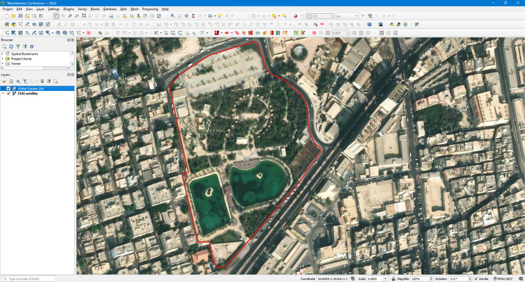
Figure 1: QGIS interface ” Water Garden Site”
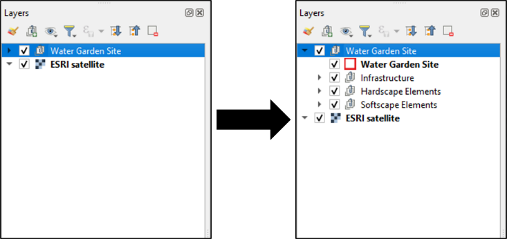
Figure 2: “Water Garden Site” to the three sub-files
d. Infrastructure Management: The infrastructure sub-file operates as archives for all network data relating to the project, including domains such as Electrical Networks, Water Supply Networks, Communication Networks, Fire Fighting Networks, Sewer Networks, and Rainwater Drainage Networks Fig 3. Visualizing these networks is simplified through interactive by clicking on any networks that will appear on the map for geolocation of all the infrastructure networks as needed for the maintenance process on the map interface Fig 4.
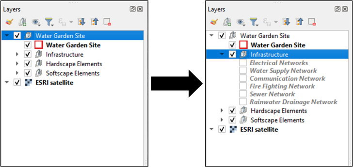
Figure 3: Infrastructure sub-file
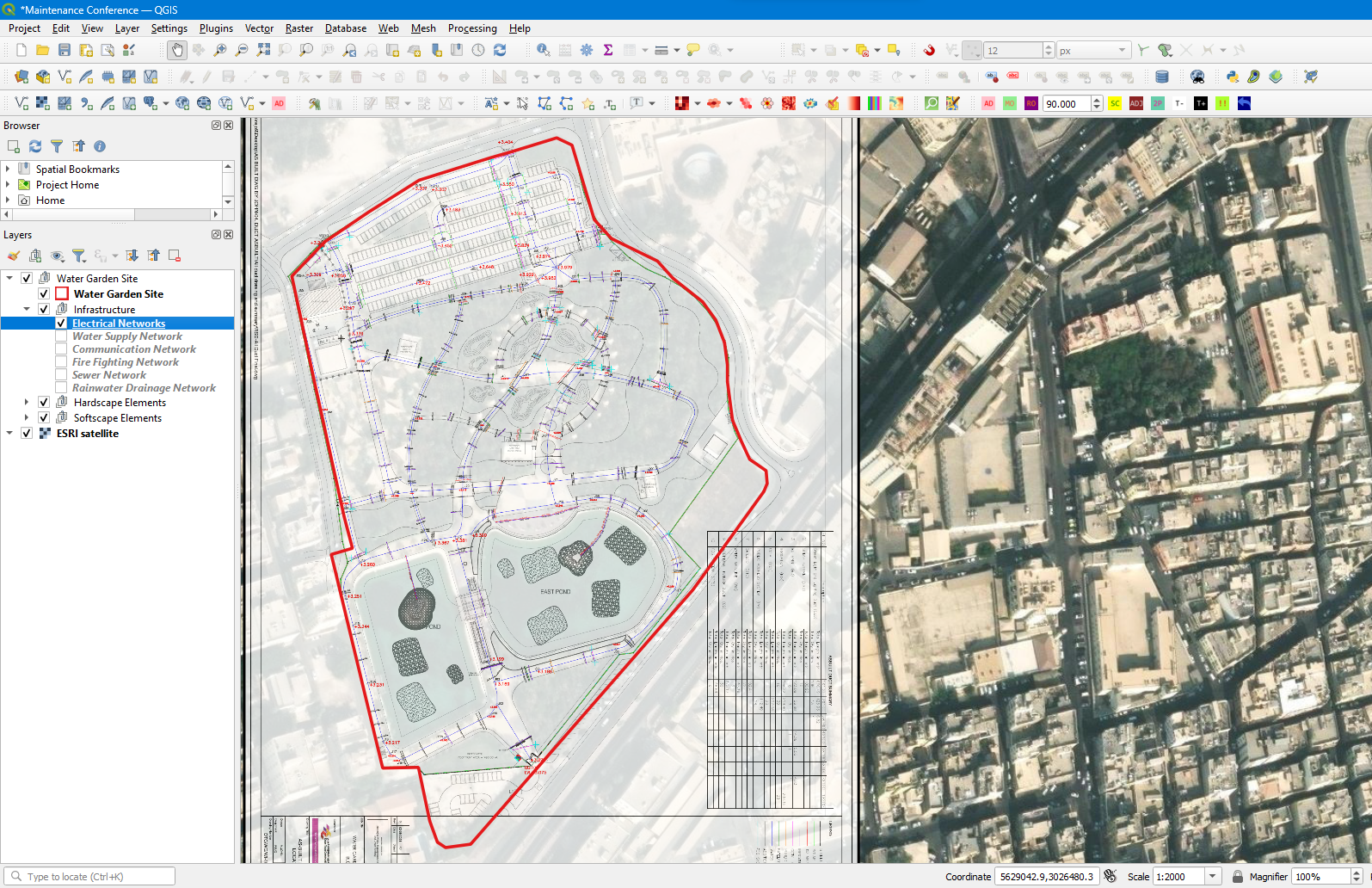
Figure 4: Electrical networks infrastructure
e. Hardscape Elements Management: The hardscape elements sub-file incorporates a comprehensive array of data detailing various hardscape components. Elements such as Lighting Networks, CCTV, Signage Boards, Benches, Waste Bins, Pavements, Artworks & Sculptures, Water Features, Steps & Ramps, and Fences & Boundary Walls are accurately cataloged in Fig 5. Interactive map points provide a direct link to information concerning each element. In the instance of the lighting network, after clicking on it, the location of its individual lighting feature displays on the map as points in Fig 6. By clicking on any of these points, a group with information for each issue will appear, including (ID, Name of The Park, Location Coordinates, Installation Date, Lifespan Left (Hours), Expiration Date, Solar Panels Schedule Cleaning, Schedule Inspection Date) Fig 7. Each sub-title from the list of Hardscape elements incorporates its own information for its points, which will aid in maintaining the hardscape elements Fig 8.
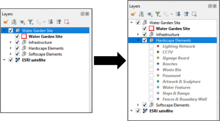
Figure 5: Hardscape elements sub-file
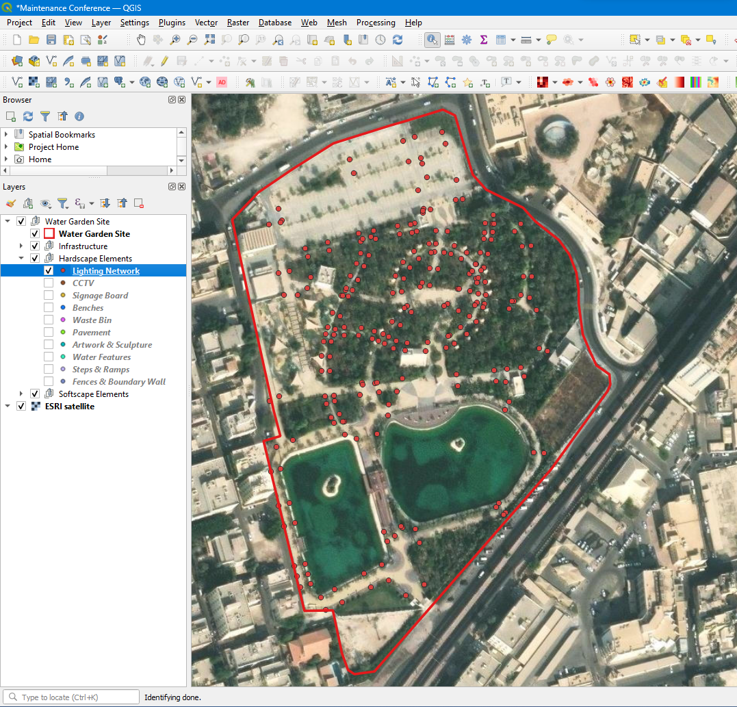
Figure 6: Lighting network layer
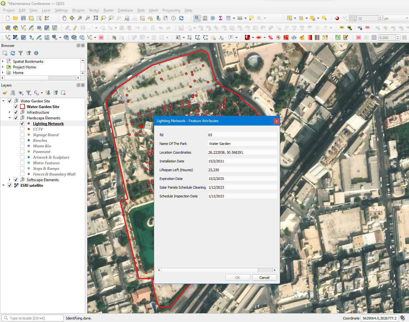
Figure 7: Lighting network element information
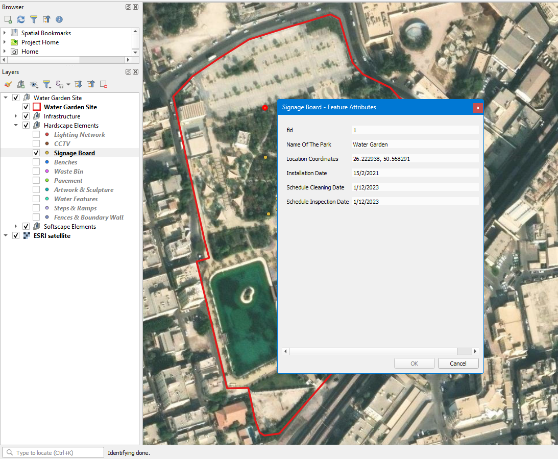
Figure 8: Signage board element information
f. Softscape Elements Management: The soft scape elements sub-file incorporates various data relating to soft scape elements such as Grass & Groundcovers, Shrubs & Hedges, and Trees & Palms Fig 9. The integration of interactive map interfaces enables the pinpointing of each component. In the instance of grass & groundcovers, after clicking on it, a group of green patches will display on the map Fig 10. By clicking on any of these green areas, a bunch of information for each area will appear, including (ID, Name of The Park, Location Coordinates, plant Type, Installation Date, Irrigation Type, Fertilizer Type & Date, Water Amount, Mower Type & Frequency, Schedule Inspection Date) Fig 11. Each sub-title from the list of soft scape elements incorporates its own information for its points or areas, which will aid in the maintenance process of the soft scape elements Fig 12.
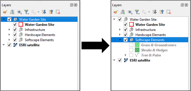
Figure 9: Softscape elements sub-file
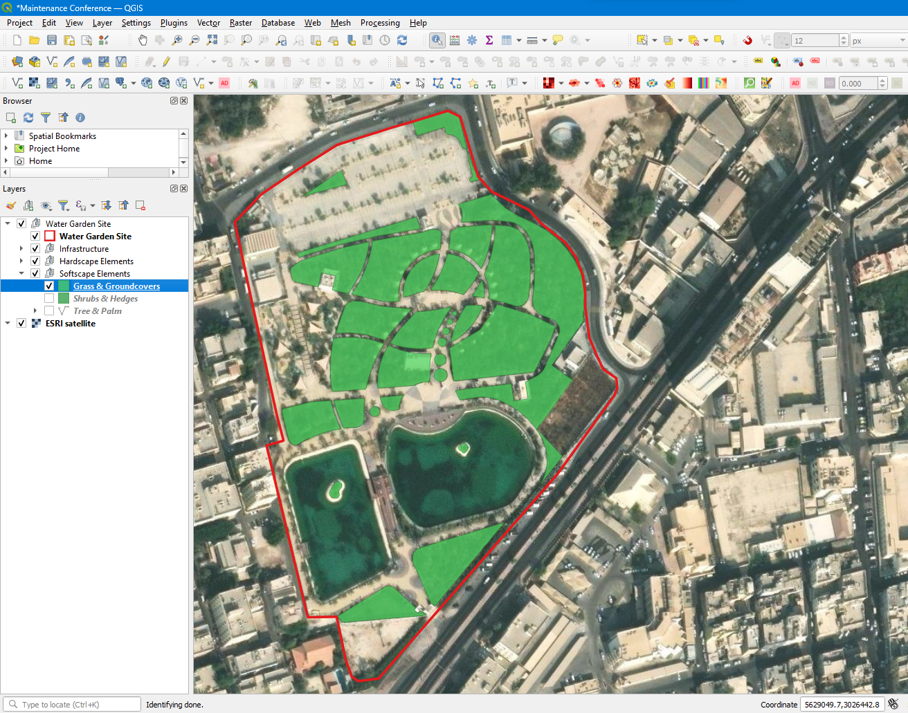
Figure 10: Grass & groundcovers layer
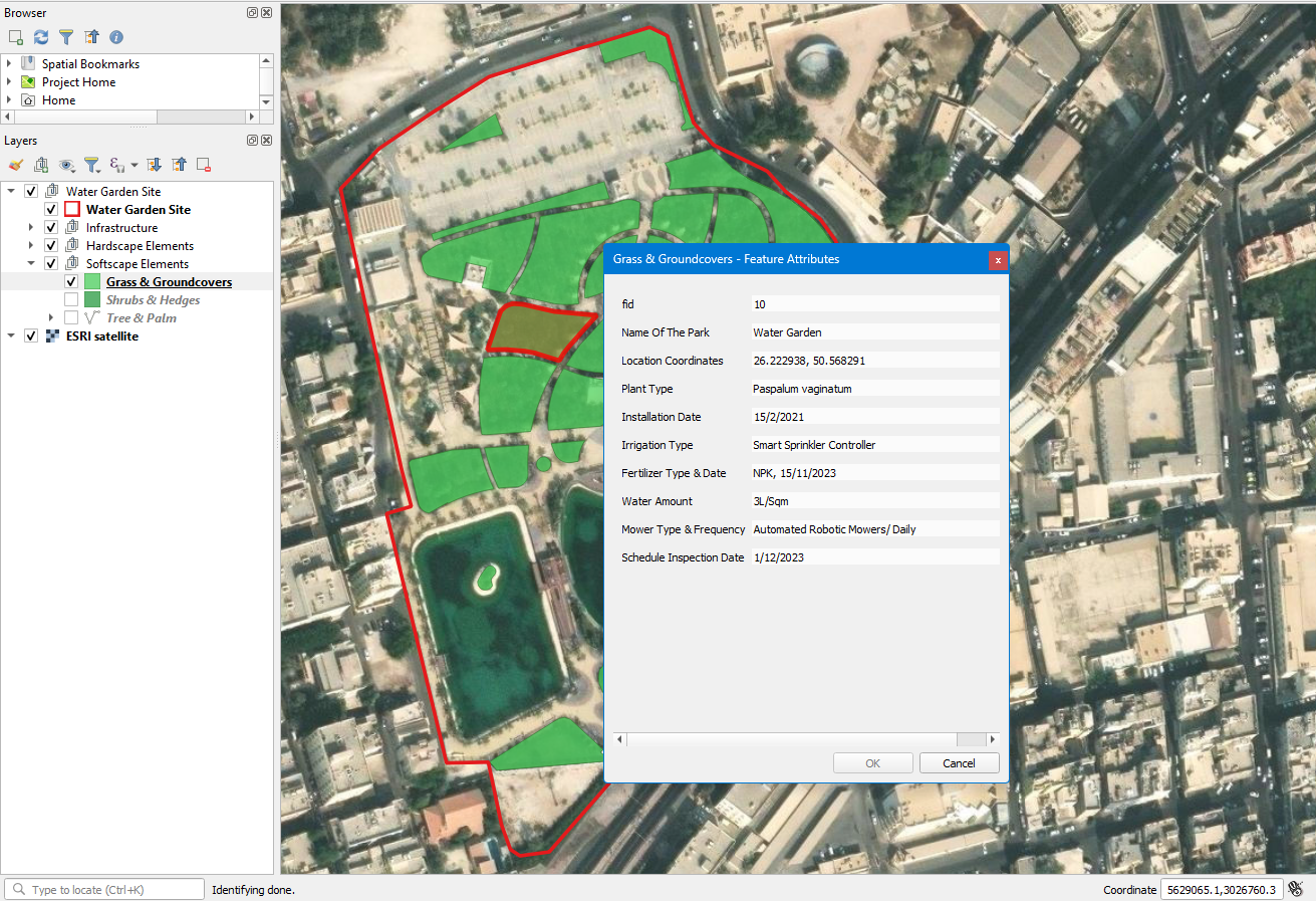
Figure 11: Grass & groundcovers element information
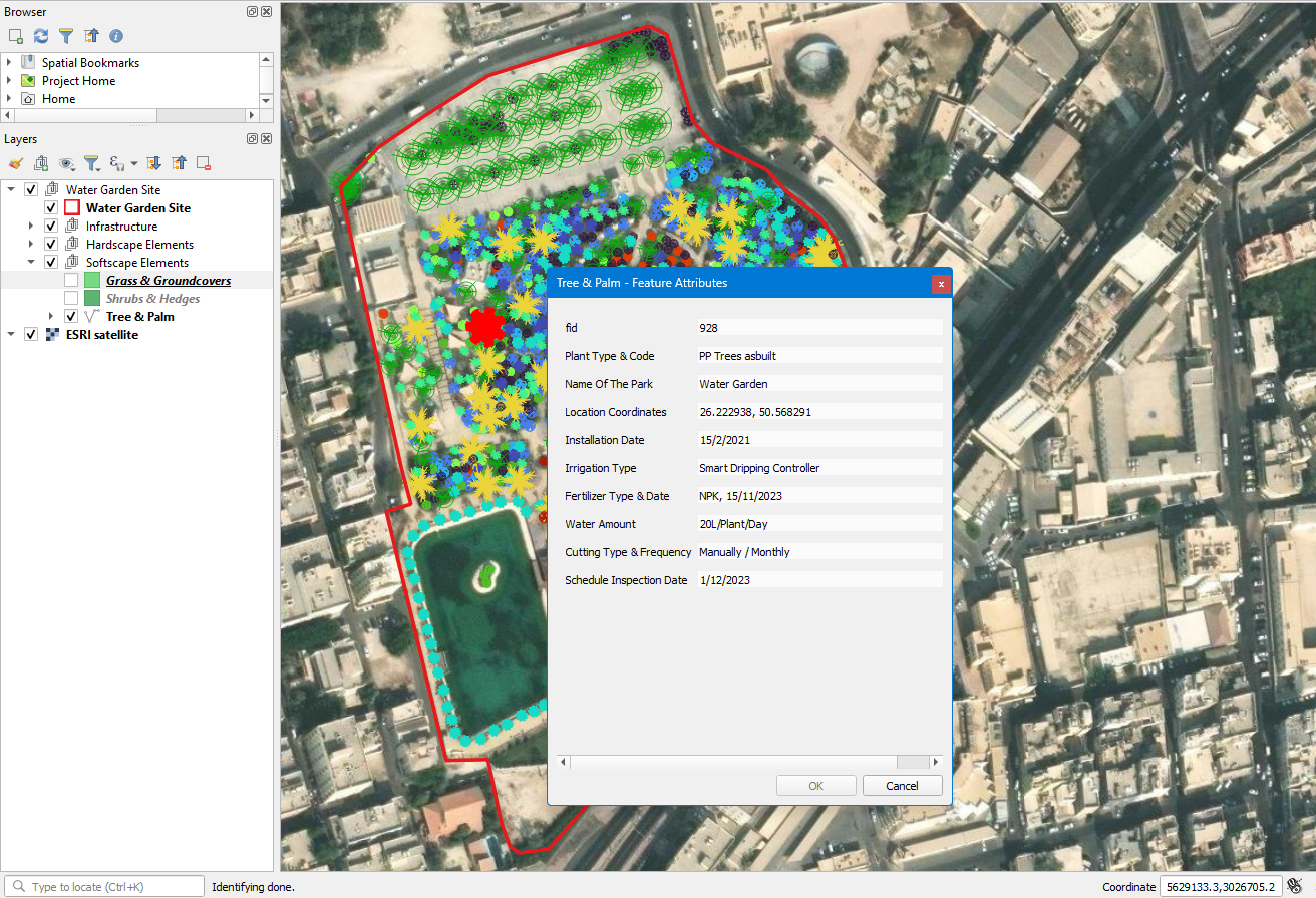
Figure 12: Tree & palm element information
5. Discussion #
Several apps and digital tools can aid in optimizing sustainable landscape maintenance techniques. These tools leverage technology and data analytics to enhance resource management, decision-making, and overall efficiency in landscape maintenance. Here are some notable apps and digital tools that can be beneficial:
- Smart Irrigation Controllers: These controllers use weather data and soil moisture sensors to adjust irrigation schedules based on real-time conditions. They help prevent overwatering and optimize water usage, leading to significant water conservation in landscape maintenance.
- Plant Identification Apps: Mobile applications that utilize image recognition technology to identify plant species can be valuable for landscape professionals. These apps assist in monitoring plant health, identifying pests or diseases, and implementing appropriate maintenance strategies for each plant type.
- Weather Monitoring Apps: Weather apps with localized and up-to-date weather forecasts are essential for landscape maintenance planning. They allow landscape managers to adjust maintenance schedules based on weather conditions, avoiding potential damage caused by extreme weather events.
- Mapping and GPS Tools: Mapping and GPS apps enable landscape architects and maintenance teams to create accurate digital maps of landscapes, marking key elements such as plants, irrigation systems, and lighting. This data aids in efficient planning, management, and tracking of maintenance tasks.
- Remote Monitoring Systems: Remote monitoring devices, such as IoT sensors and cameras, provide real-time data on environmental conditions, including temperature, humidity, and light levels. These tools help identify maintenance needs, such as irrigation adjustments or pest control, in a timely manner.
- Data Analytics Platforms: Advanced data analytics platforms can process and analyze the vast amounts of data collected from various sources, such as sensors and weather reports. These platforms offer insights into landscape performance, enabling landscape architects to make data-driven decisions for maintenance and future design improvements.
- Mobile Task Management Apps: Task management apps facilitate communication and coordination among maintenance teams. These apps allow landscape professionals to assign tasks, track progress, and receive updates in real-time, streamlining the maintenance workflow.
- Sustainable Material Sourcing Apps: For sustainable landscape design and maintenance, apps that provide information on eco-friendly and locally sourced materials are valuable. These apps aid in choosing environmentally responsible materials for landscape projects.
- Green Waste Recycling Apps: Apps that connect landscape professionals with green waste recycling facilities help ensure responsible disposal and recycling of landscape waste, reducing environmental impact.
- Carbon Footprint Calculators: Carbon footprint calculators enable landscape managers to assess and quantify the environmental impact of maintenance practices. Professionals can implement strategies to minimize the landscape’s overall carbon footprint by measuring carbon emissions.
Integrating these apps and digital tools into landscape maintenance practices empowers landscape architects and maintenance teams to achieve more efficient, sustainable, and data-informed approaches to landscape management in the Arab region and beyond.
6. Results #
The integration of digital tools and data analytics in sustainable landscape maintenance practices marks a transformative shift towards more efficient, resource-conscious, and ecologically responsible urban environments. The research findings underscore the value of technology-driven approaches in water conservation, resource efficiency, and landscape health. By adopting data-driven decision-making and fostering community engagement, cities in the Arab region can build a more sustainable future that balances urban development with environmental preservation. The research paper provides valuable insights for landscape professionals, policymakers, and city planners, guiding them toward innovative and evidence-based strategies for sustainable landscape maintenance, contributing to the well-being and resilience of urban communities in the Arab region. The major result of the research is as follows:
6.1 Impact of Digital Tools on Water Conservation:
The analysis of survey data and field observations revealed a significant positive impact of digital tools on water conservation in sustainable landscape maintenance practices. The implementation of smart irrigation controllers, connected to weather data and soil moisture sensors, resulted in optimized irrigation schedules and reduced water wastage. Across the case studies, water consumption in parks, green spaces, and urban oases decreased by an average of 25% to 30%, demonstrating the effectiveness of digital tools in promoting water-efficient practices.
6.2 Resource Efficiency and Cost Savings:
The integration of remote monitoring systems, such as IoT sensors and cameras, enabled real-time tracking of environmental parameters and plant health. The data collected facilitated timely responses to maintenance issues, leading to more efficient resource allocation and reduced maintenance costs. Smart lighting control systems and automated robotic mowers also contributed to energy savings and lowered operational expenses, making landscape maintenance more economically sustainable in urban environments.
6.3 Improved Landscape Health and Biodiversity:
The native plant identification apps used in restoration projects and urban green spaces contributed to the successful management of plant species. Early detection of pests, diseases, or nutrient deficiencies allowed for timely intervention and improved plant health. The restoration efforts in degraded landscapes resulted in increased biodiversity, showcasing the potential of digital tools in promoting ecological preservation and enhancing the resilience of urban ecosystems.
6.4 Data-Driven Decision-Making:
The adoption of data analytics platforms provided valuable insights into landscape performance, water usage trends, and resource efficiency. Landscape architects and maintenance professionals were empowered to make informed decisions based on data-driven analysis, enhancing the effectiveness of maintenance practices and promoting evidence-based approaches.
6.5 Community Engagement and Public Participation:
Using mobile apps to report maintenance issues in public parks fostered community engagement and public participation. Park visitors’ active involvement in reporting and identifying landscape maintenance needs contributed to a sense of ownership and community pride, resulting in improved park upkeep and cleanliness.
6.6 Enhancing Landscape Health and Biodiversity:
The successful implementation of native plant identification apps and ecosystem restoration projects showcased the potential of digital tools in promoting landscape health and biodiversity. The early detection of plant health issues facilitated timely interventions, preventing the spread of diseases and enhancing overall vegetation quality. Restoration efforts in degraded landscapes contributed to increased biodiversity, highlighting the role of technology-driven approaches in preserving ecosystems and fostering urban resilience.
6.7 Overcoming Challenges and Future Directions:
The research also identified challenges in the adoption of digital tools, including initial investment costs, technology integration, and training needs. To address these challenges, stakeholders must collaborate and invest in smart city initiatives that prioritize sustainable landscape management. Continuous research and innovation in landscape architecture and technology will drive advancements, making digital tools more accessible, user-friendly, and cost-effective.
6.8 Broader Implications for Urban Sustainability:
The results of this research have broader implications for urban sustainability in the Arab region and beyond. Sustainable landscape maintenance practices enhance the aesthetic appeal of cities and contribute to ecological preservation, resource conservation, and climate resilience. By embracing technology-driven approaches, cities can create greener, healthier, and more livable environments for their residents, aligning with global efforts towards achieving the United Nations Sustainable Development Goals.
7. Conclusion #
In conclusion, the incorporated approach to landscape project maintenance management, empowered by the QGIS application, results in a streamlined, sustainable, and effective system. The combination of spatial data analysis capabilities with user-friendly digital mapping interfaces ushers in a new era of maintenance precision and resource optimization. Using QGIS to enhance landscape project maintenance represents a transformative leap toward modernity and sustainability. The structured process outlined above underscores the fundamental value of QGIS in complicated, complex spatial data, assisting informed decision-making and facilitating accurate resource allocation. This comprehensive strategy has numerous advantages for the maintenance process:
- Efficiency: QGIS streamlines data accumulation, visualization, and analysis, resulting in optimized resource utilization and swift decision-making.
- Transparency: The transparent mapping of infrastructure and elements empowers maintenance personnel with real-time, actionable insights, augmenting their operational efficacy.
- Sustainability: By enabling accurate tracking of maintenance schedules, resource consumption, and plant health, QGIS contributes to ecologically conscious maintenance practices.
- Cost Savings: The targeted allocation of resources, informed by QGIS-generated data, translates to reduced operational costs and continued infrastructure lifespan.
- Enhanced Communication: QGIS-generated visualizations facilitate effective communication between stakeholders, engendering a shared understanding of maintenance significances.
The research paper contributes to the growing knowledge of sustainable landscape maintenance and offers practical guidance, valuable insights, and a foundation for future research endeavors. By promoting the use of technology, data, and community engagement, the paper advocates for a more resilient and ecologically conscious urban landscape that contributes to the overall well-being and quality of life of inhabitants in the Arab region.
Moreover, it has explored the critical role of digital tools in advancing sustainable landscape maintenance practices in the Arab region. By integrating innovative technology, data analytics, and geospatial mapping, landscape professionals and policymakers can enhance landscape management’s efficiency, effectiveness, and environmental responsibility. The research has shed light on the significance of technology-driven approaches in achieving landscape sustainability and addressing the challenges faced in arid regions. Through a comprehensive literature review, the paper has established the importance of embracing innovative solutions for landscape maintenance, considering the need for resilient green infrastructure. By analyzing past studies and case studies from various Arab cities, the paper has presented evidence of the positive impact of digital tools on water conservation, energy efficiency, biodiversity preservation, and community engagement.
The research findings highlight that digital tools optimize resource allocation and empower communities to actively participate in landscape maintenance actively, fostering a sense of ownership and responsibility for public green spaces. Moreover, the paper underscores the value of using intelligent techniques like QGIS in real-time data monitoring and analytics, enabling evidence-based decision-making and adaptive management practices for sustainable landscapes. In the context of the Arab region, the research has emphasized the need for context-specific solutions, acknowledging the unique environmental, cultural, and social factors that influence landscape management. Integrating digital tools in this context should be aligned with local practices, regulations, and community preferences to ensure long-term success and relevance.
In conclusion, the paper calls for continued collaboration between researchers, practitioners, policymakers, and citizens to collectively work toward establishing intelligent, sustainable, and vibrant green spaces that enrich the urban fabric and safeguard the environment for future generations. By embracing innovation and staying adaptive, the Arab region can lead the way in landscape sustainability and set an inspiring example for other global communities facing similar challenges.
| 1. Smart Irrigation Controllers. | 2. Plant Identification Apps. |
| 3. Weather Monitoring Apps. | 4.Mapping and GPS Tools. |
| 5. Remote Monitoring Systems. | 6. Data Analytics Platforms. |
| 7. Mobile Task Management Apps. | 8. Sustainable Material Sourcing Apps. |
| 10. Green Waste Recycling Apps. | 11. Carbon Footprint Calculators. |
Integrating such digital tools and data analytics in sustainable landscape maintenance practices marks a transformative shift towards more efficient, resource-conscious, and ecologically responsible urban environments. The research findings underscore the value of technology-driven approaches in water conservation, resource efficiency, and landscape health. By adopting data-driven decision-making and fostering community engagement, cities in the Arab region can build a more sustainable future that balances urban development with environmental preservation.
8. Challenges and Recommendations: #
Despite the positive outcomes, the research illustrated several challenges in the adoption of digital tools, including the initial investment costs, technology integration, and training needs. However, the long-term benefits of water and resource savings, improved landscape health, and enhanced public spaces outweighed the initial challenges.
The research paper recommends that landscape professionals, policymakers, and city planners prioritize the integration of digital tools and data analytics in sustainable landscape maintenance strategies. Collaborative efforts between public and private sectors should focus on developing and implementing smart systems initiatives that promote sustainable landscape management for operation and maintenance, thereby enhancing the quality of maintenance performance in outdoor spaces in general and parks in particular in the Arab region. Continued research and innovation in the field of landscape architecture and technology will play a vital role in advancing the sustainability and efficiency of landscape maintenance practices in the future.
References: #
- “Education city”, AECOM. Available at: https://aecom.com/projects/education-city-landscape-design-middle-east/, (undated).
- “Explore Qatar’s Education City”, QF Stories RSS. Available at: https://www.qf.org.qa/education/education-city, (undated)..
- “King Salman Park”, Omrania. Available at: https://omrania.com/project/king-salman-park/, (2021)
- “Sharaan Nature Reserve” Royal Commission For AlUla, Available at: https://www.rcu.gov.sa/en/fact-sheets/sharaan-nature-reserve/, (undated).
- “Smart watering with soil moisture-based irrigation controllers”, Available at: https://www.epa.gov/sites/default/files/2021-04/documents/ws-outdoor-products-sms_mini-report.pdf, (2021).
- “Strategy and the execution plan of ecosystem restoration and agroforestry for Al Ula IUCN”. Available at: https://www.iucn.org/our-work/region/west-asia/our-work/drylands-livelihood-and-gender-programme/strategy-and-execution, (2023).
- “Sustainable Water Management Assessment and Recommendations for the Emirate of Abu Dhabi”, SIPA, Available at: https://www.sipa.columbia.edu/sites/default/files/migrated/migrated/documents/AbuDhabiFinalReport_0.pdf, (2020).
- A S A Al Mashhadani “Sustainable greening of Abu Dhabi City”, Proceedings of 3rd International Conference – Geosynthetics ME, Abu Dhabi, UAE. Available at: https://www.academia.edu/10828336/SUSTAINABLE_GREENING_OF_ABU_DHABI_CITY, (2015).
- A. Ahmed, Q. Al-Amin, “Sustainable urban landscape management using IoT: A case study of Dubai Parks and Resorts”. Sustainable Cities and Society, (2020).
- A. L. Cariou, “The mutation of an agricultural oasis into a strategic reserve dedicated to a secure water supply for Abu Dhabi”, SpringerLink. Available at: https://link.springer.com/chapter/10.1007/978-3-319-50749-1_12, (1970).
- A. N. Tiwary, “GIS and Remote Sensing in Urban Development Planning” Available at: https://www.semanticscholar.org/paper/GIS-and-Remote-Sensing-in-Urban-Development-Issues-Tiwary/04fa69a4ad58852a8fa063181f7682922bd54f36, (2016).
- A. RAHMAN, M NETZBAND,. “An assessment of urban environmental issues using remote sensing” Available at: https://www.ciesin.columbia.edu/repository/pern/papers/urban_pde_rahman_etal.pdf, (2007).
- A., “King Salman Park Project”, Royal commission for Riyadh, Available at: https://www.rcrc.gov.sa/en/projects/king-salman-park-project, (2023).
- A., Alsharif, & Z, S. Rahmati “Optimizing irrigation water management in arid regions using a smart decision support system: A case study of Al-Ula, Saudi Arabia”, Computers and Electronics in Agriculture, (2021).
- A., Hafian, M. Benbrahim, M.N. Kabbaj, “Design and implementation of smart irrigation system based on the IOT Architecture”, SpringerLink. Available at: https://link.springer.com/chapter/10.1007/978-3-030-73882-2_32, (2021).
- C. Yue, et al. “Landscape Irrigation and water conservation in urban areas: An analysis of information-based strategies”, horttech. Available at: https://journals.ashs.org/horttech/view/journals/horttech/32/2/article-p213.xml, (2022).
- D. Aly, B. Dimitrijevic, “Public Green Space Quantity and distribution in Cairo, Egypt”, Journal of Engineering and Applied Science, SpringerOpen. Available at: https://jeas.springeropen.com/articles/10.1186/s44147-021-00067-z, (2022)
- D.A., Janahi, Z. Abdulsaheb, I. H. Elghonaimy, “The use of attractive lights to encourage the public of using the outdoor areas to control the spreading of COVID 19”, IET Digital Library. Available at: https://digital-library.theiet.org/content/conferences/10.1049/icp.2021.0969, (2021).
- D.M. Bajany, et al. “Optimisation approach toward water management and energy security in arid/semiarid regions – environmental processes”, SpringerLink. Available at: https://link.springer.com/article/10.1007/s40710-021-00537-9, (2021).
- D.P. Patel,et al. “Decision Support System integrated with Geographic Information System to target restoration actions in watersheds of arid environment: A case study of Hathmati watershed”, Sabarkantha district, Gujarat. Available at: https://www.ias.ac.in/article/fulltext/jess/124/01/0071-0086, (2015).
- G.M. Joyce, J.S. Priyadarshini, “Analogizing the role of IOT and data analytics for smart irrigation and Aquaculture”, SpringerLink. Available at: https://link.springer.com/chapter/10.1007/978-981-19-9304-6_36, (2023).
- Green Riyadh, Vision 2030. Available at: https://www.vision2030.gov.sa/v2030/v2030-projects/green-riyadh/, (Undated).
- I.H. El Ghonaimy, W. Mohammed, “Urban heat islands in Bahrain: An urban perspective, Buildings”. Available at: https://www.academia.edu/38904775/Urban_Heat_Islands_in_Bahrain_An_Urban_Perspective, (2022).
- I.H. Elghonaimy, “Sustainable e-operation for university campus; G.I.S contribution”, Proceedings of the International Conference on Industrial Engineering and Operations Management. Available at: http://ieomsociety.org/southafrica2018/papers/107.pdf, (2018).
- I.H. Elghonaimy, “Urban Design for university campuses in Arab countries”. Available at: https://www.researchgate.net/publication/321025982_Urban_Design_for_University_Campuses_in_Arab_Countries, (2017).
- I.H. Elghonaimy, D.H. Eldardiry, “Digitalization and reviving the water frontage following the concept of smart cities after covid 19 pandemic”, IET Digital Library. Available at: https://digital-library.theiet.org/content/conferences/10.1049/icp.2022.0376, (2021).
- I.H. Elghonaimy, D.H. Eldardiry, “Greenery in Cities and Controlling the Reasons of Urban Heat Islands – a Sustainable Approach for the Spaces of the Future in Controlling Urban Heat Islands”. Available at: https://www.researchgate.net/publication/341734659_Greenery_in_Cities_and_Controlling_the_Reasons_of_Urban_Heat_Islands_-a_Sustainable_Approach_for_the_Spaces_of_the_Future_in_Controlling_Urban_Heat_Islands, (2020).
- I.H. Elghonaimy, Mahmoud, W.E. “Sustainability and G.I.S. Application in Operating Smart Campuses in the Smart Cities”, https://doi.org/10.1049/cp.2019.0208 . Available at: https://www.researchgate.net/publication/336355247_Sustainability_and_GIS_Application_in_Operating_Smart_Campuses_in_the_Smart_Cities, (2019).
- J. Martin, “Masdar City: Abu Dhabi’s ‘greenprint’ for sustainable cities”, Investment Monitor. Available at: https://www.investmentmonitor.ai/sponsored/masdar-city-greenprint-for-sustainable-cities/, (2022).
- J. Roldán-Cañas, M.F. Moreno-Pérez, “Water and irrigation management in arid and semiarid zones”, MDPI. Available at: https://www.mdpi.com/2073-4441/13/17/2446/htm, (2021).
- J. Shan, et al. “Green Space Planning and landscape sustainable design in Smart Cities considering public green space demands of different formats”, Complexity. Available at: https://www.hindawi.com/journals/complexity/2021/5086636, (2021).
- K.M. Shurtz,et al. “Insights into efficient irrigation of urban landscapes: Analysis using remote sensing, parcel data, water use, and tiered rates”, MDPI. Available at: https://www.mdpi.com/2071-1050/14/3/1427/htm, (2022).
- L. Jun , Y. Danlin , X. Miao, “Modeling urban growth using GIS and remote sensing”. Available at: https://www.tandfonline.com/doi/abs/10.2747/1548-1603.45.4.426, (2013).
- M. A., Salem, M. A. Al-Haddad, “Smart maintenance of landscape infrastructure in Masdar City, Abu Dhabi”, Procedia Computer Science, (2019).
- M. Abdallah, et al. “simulation and optimization of dynamic waste collection routes”. SciSpace – Paper. Available at: https://typeset.io/papers/simulation-and-optimization-of-dynamic-waste-collection-3rmpfx58xu (2019).
- M. M., Kandil, El-Hadidy, M. A. “Smart irrigation system for urban green spaces using IoT”. Procedia Computer Science, (2021).
- M., Al-Harbi, & M. Al-Zuair, “Smart Park management system for Riyadh city using IoT”, Journal of King Saud University-Computer and Information Sciences, (2021).
- M., Imhemed, B. Conrard, M Bayart,. “An intelligent automatic irrigation system for Arid Region”, SpringerLink. Available at: https://link.springer.com/chapter/10.1007/978-3-030-13697-0_17, (2019).
- M.A. Abdelfattah, “Land degradation indicators and management options in the desert … – soil”. Available at: https://www.soils.org/files/publications/soil-survey-feature-spring-2009.pdf, (2009).
- M.M. El-Bastawisy, “Applying green urbanism during spatial urban transformation: A schematic plan, Nasr City, Cairo, Egypt”, Rendiconti lincei. Scienze Fisiche e naturali, SpringerLink. Available at: https://link.springer.com/article/10.1007/s12210-023-01134-8, (2023).
- M.M., Keleg, G.B. Watson, M.A. Salheen, “A critical review for Cairo’s Green Open Spaces Dynamics as a prospect to act as placemaking anchors”, urban design international, SpringerLink. Available at: https://link.springer.com/article/10.1057/s41289-022-00193-x, (2022).
- M.S. Boori, et al. “Monitoring and modeling of urban sprawl through Remote Sensing and GIS in Kuala Lumpur, Malaysia – ecological processes”, SpringerOpen. Available at: https://ecologicalprocesses.springeropen.com/articles/10.1186/s13717-015-0040-2, (2015).
- Masdar City supports UAEs carbon neutrality goals with new Masdar City, Available at: https://news.masdar.ae/en/News/2022/06/24/07/20/Masdar-City-Supports-UAEs-Carbon-Neutrality-Goals-with-New-Masdar-City-Square, (2022).
- O. Geray, “An impact-driven Smart Sustainable City Framework to address urban challenges: Smart Dubai experience”, Available at: https://link.springer.com/chapter/10.1007/978-981-13-2011-8_3, (1970).
- P. Caballero, “Oxygen Park / AECOM”, Arch Daily. Available at: https://www.archdaily.com/976389/oxygen-park-aecom, (2022).
- P. Caratelli, “Are garden cities in the desert sustainable? The Oasis City of Al Ain in the Emirate of Abu Dhabi, Available at: https://www.academia.edu/43758713/Are_Garden_Cities_in_the_Desert_Sustainable_The_Oasis_City_of_Al_Ain_in_the_Emirate_of_Abu_Dhabi, (2020).
- P. Kianmehr, A. Jishi, “Sustainable coastal landscaping using reclaimed irrigation water in Dubai”, Journal of Geoscience and Environment Protection. Available at: https://www.scirp.org/journal/paperinformation.aspx?paperid=121476, (2022).
- R. AL-Dabbagh, “Dubai, the sustainable, Smart City”, Research gate. Available at: https://www.researchgate.net/publication/357624367_Dubai_the_sustainable_smart_city/fulltext/61d6e6a7da5d105e5520be2f/Dubai-the-sustainable-smart-city.pdf, (2022).
- R. Ullah, et al. EEWMP: “An IOT-based energy-efficient water management platform for smart irrigation”, Scientific Programming. Available at: https://www.hindawi.com/journals/sp/2021/5536884/, (2021).
- S. M. Al-Masri, & S. Alsaaq, “Data-driven campus landscape design and maintenance in Qatar: A case study of Education City”. Sustainable Cities and Society, (2020).
- S. Walia, J. Sengupta, “A proposal of IOT based evapotranspiration irrigation system for water conservation”, SpringerLink. Available at: https://link.springer.com/chapter/10.1007/978-981-19-0284-0_34, (1970).
- S.B. Ansari, “Smart Solutions for Urban Parks Management” (m.arch thesis report), Available at: https://www.academia.edu/76744879/Smart_Solutions_for_Urban_Parks_Management_by_Sadaf_Bilal_Ansari_M_Arch_Thesis_Report_?f_ri=1130342, (2022).
- S.H. Mahmoud, A.A. Alazba, “The potential of in situ rainwater harvesting in arid regions: Developing a methodology to identify suitable areas using GIS-based decision support system”, Arabian journal of geosciences, SpringerLink. Available at: https://link.springer.com/article/10.1007/s12517-014-1535-3, (2014).
- Smart waste Bin Fill: “Level sensor Waste Solutions”. Available at: https://waste.solutions/technology/smart-sensors/. (2022)
- T. Ali, et al. “IOT-based Smart Waste Bin Monitoring and municipal solid waste management system for smart cities” – Arabian journal for science and engineering, SpringerLink. Available at: https://link.springer.com/article/10.1007/s13369-020-04637-w, (2020).
- The Royal Commission for AlUla (RCU) Royal Commission for AlUla, Home. Available at: https://www.rcu.gov.sa/en, (undated).
- V. Sankaran, A. Chopra, “Creating global sustainable smart cities, a case study of Masdar City”, Scinapse. Available at: https://www.scinapse.io/papers/3113469644, (2020).


